selle en cogles

CANON2
User
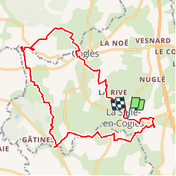

Length
19.2 km

Max alt
128 m

Uphill gradient
197 m
Km-Effort
22 km

Min alt
88 m

Downhill gradient
198 m
Boucle
Yes
Creation date :
2019-05-15 13:09:35.676
Updated on :
2019-05-15 13:09:35.756
4h48
Difficulty : Medium

FREE GPS app for hiking
 SityTrail
IGN / Geographical institutes
SityTrail Plus
The world is yours!
About
Trail Walking of 19.2 km to be discovered at Brittany, Ille-et-Vilaine, Les Portes du Coglais. This trail is proposed by CANON2.
Positioning
Country:
France
Region :
Brittany
Department/Province :
Ille-et-Vilaine
Municipality :
Les Portes du Coglais
Location:
Unknown
Start:(Dec)
Start:(UTM)
622528 ; 5366271 (30U) N.
Comments